SOLANO COUNTY
Top Ten
Walks &
Hikes
Top Ten
Walks &
Hikes
1
2
3
4
5
6
9
7
8
10
505
80
80
80
80
80
680
680
680
780
12
12
29
29
37
12
12
4
4
113
113
128
128
128
121
MARTINEZ
CROCKETT
BENICIA
VALLEJO
NAPA
FAIRFIELD
DIXON
CORDELIA
SUISUN
CITY
RIO VISTA
VACAVILLE
WINTERS
DAVIS
Napa County
Solano County
Yolo County
Contra Costa County
0 10 Miles5
1
2
3
4
5
6
7
8
9
10
1st Street Benicia................................................
Rio Vista Bridge to Beach Trail...........................
Rush Ranch..........................................................
Vacaville Creek Walk..........................................
Blue Rock Springs...............................................
Rockville Hills......................................................
Hiddenbrooke.....................................................
Lagoon Valley......................................................
Lynch Canyon......................................................
Stebbins Cold Canyon.......................................
page
2
2
3
4
5
6
7
8
9
10
Easy Walking Route
Moderate Walking or Hiking Route
Strenuous Hiking Route
N
1
12
12
RIO VISTA
Bruning
Park
Sandy Beach
County Park
Buena
Vista
Park
Helen
Madere
Memorial
Bridge
Rio Vista
Fishing
Pier
Rio Vista
Museum
Rio Vista
Library
City
Hall
North Front Street
Crescent Drive
Main
Street
Main Street
Montezuma Street
Center Street
California Street
Bruning Avenue
Edgewater Drive
South Front
Street
South 2nd Street
South
Gertrudes
Avenue
Riverview
Street
Hamilton Avenue
South Front Street
South 7th Street
South 6th
Street
North 4th
Street
North 2nd Street
Crescent Drive
Logan Street
Sacramento Street
M
o
n
t
e
z
u
m
a
H
i
l
l
s
R
o
a
d
optional route
continue to
Sacramento River
1.5
1
.5
B
Carquinez Strait
BENICIA
Kuhland Alley
East E Street
West F Street
West H Street
Semple
Crossing
West I Street
West J Street
West K Street
East K Street
Military West
East H Street
East I Street
East G Street
East F Street
Walnut
Maple
Palm
East D Street
East B Street
1st Street
1st Street
West 2nd Street
East 2nd Street
Aspen
Birch
Fitzgerald
Field
Benicia
Point
Turnbull
Park
Benicia
Capitol
State
Historic
Park
City
Park
Eunice
Jensen
Park
Playground
of Dreams
Benicia
Public
Library
Benicia
Veterans
Memorial
Hall
Fishing
Pier
Benicia Marina
.5
1
B
B
B
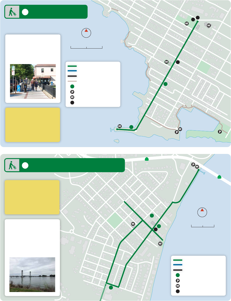
2 Rio Vista Bridge to Beach Trail
1 1st Street Benicia
0 1000 Feet500
0 500 Feet250
N
N
Difficulty Easy
Distance 2.5 Miles
Type Out and Back
Public Transit SolTrans
Quick Facts
Quick Facts
Difficulty Easy
Distance 2 Miles
Type Loop
Public Transit Delta Breeze
Quick Facts
Quick Facts
2
In addition to historical
sights and recreation
areas, you will find plenty
of antique shops, cafes,
bars, and other retail
establishments.
Its compact size and easy
rolling hills make Rio Vista
a great place for walking
and biking. As you enjoy
your stroll through town,
take a moment to admire
the historic architecture
and scenic river views.
Easy Walking Route
Moderate Walking Route
Strenuous Hiking Route
Mileage
Parking
Restrooms
Bus Stop
1
B
Easy Walking Route
Moderate Walking Route
Strenuous Hiking Route
Other Trail
Mileage
Parking
Restrooms
Bus Stop
1
B
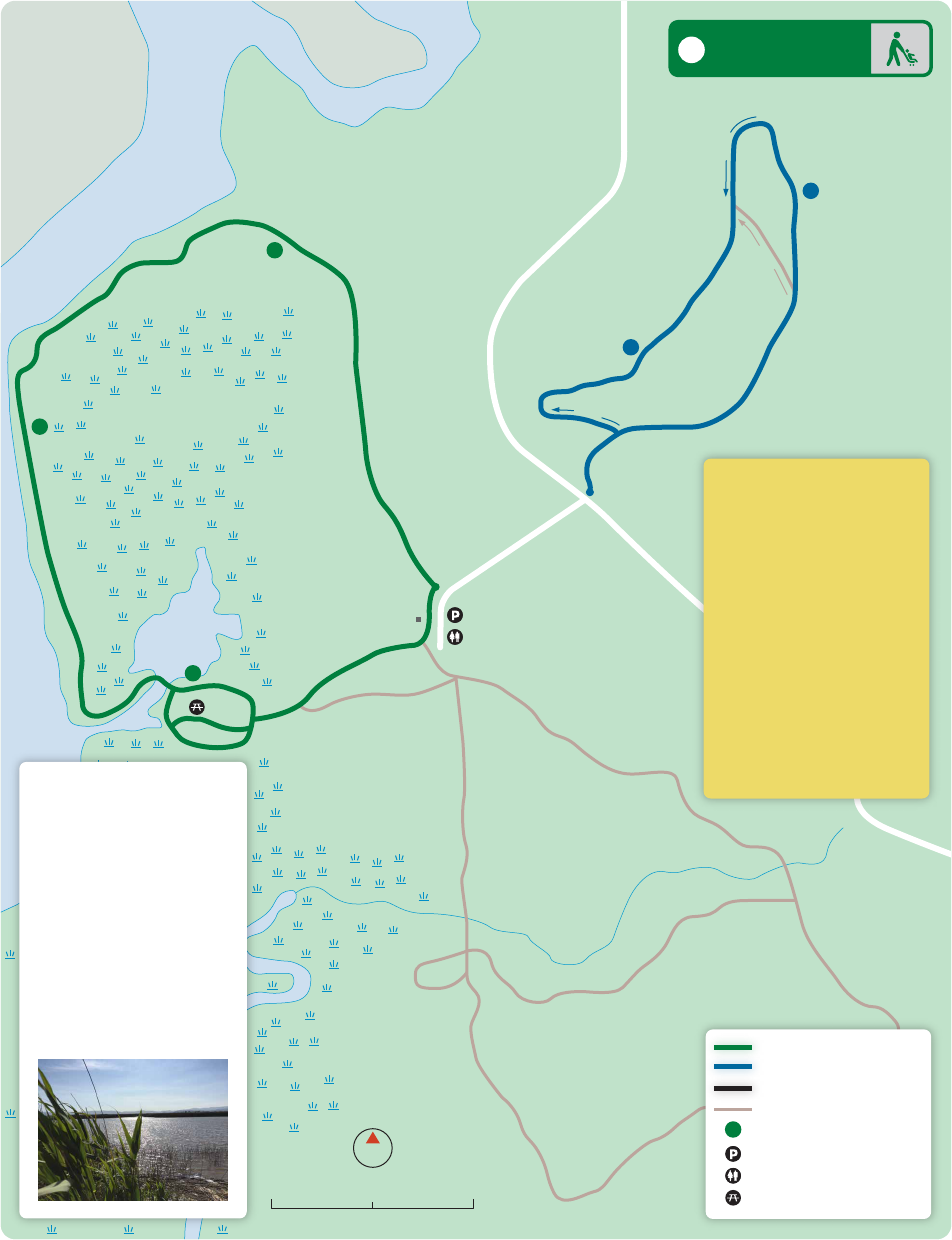
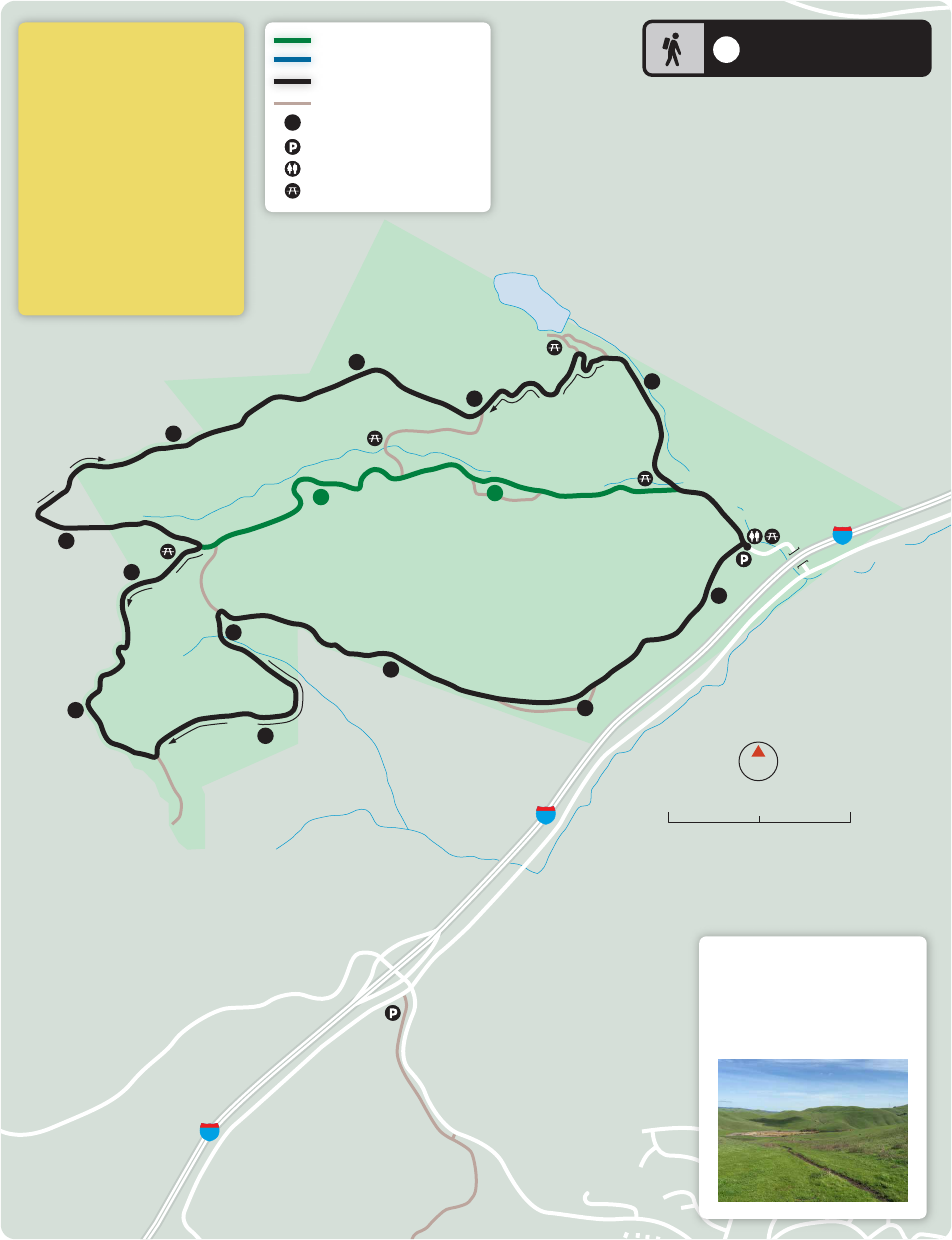
Rush Ranch
Open Space
Rush Ranch
Open Space
Grizzly Island Road
Grizzly Island Road
Marsh Trail
Marsh Trail
S
u
i
s
u
n
H
i
l
l
T
r
a
i
l
S
o
u
t
h
P
a
s
t
u
r
e
T
r
a
i
l
S
o
u
t
h
P
a
s
t
u
r
e
T
r
a
i
l
Rush
Ranch
u
p
h
i
l
l
uphill
u
p
h
i
l
l
Goat Island Marsh
Suisun Slough
Suisun Marsh
For an easy walk, take
the Marsh Trail by heading
west and around the hill
to see the edge of the tidal
marsh and a replica of a
Patwin shelter. Climb the
hill for views of the
Suisun Marsh.
On the Suisun Hill Trail,
head toward the hills and,
at the first fork, turn left for
a 500-foot climb to an over-
look with expansive views
of Mount Diablo, Suisun
Marsh, and the western
hills of Solano County.
0 0.25 Mile0.125
N
Difficulty Easy
Distance Marsh Trail - 2 Miles
Suisun Hill Trail - 1.5 Miles
Type Loops
Path Material Dirt
Dog Friendly Suisun Hill Trail
Parking Free
Public Restrooms Yes
Picnic Area Yes
Public Transit No
Hours 8 am-5 pm (Nov-Feb)
Quick Facts
Quick Facts
and visitors
center only
8 am-7 pm (Mar-Oct)
Easy Walking Route
Moderate Walking Route
Strenuous Hiking Route
Other Trail
Mileage
Parking
Restrooms
Picnic Area
.5
1
1
1.5
.5
1
3 Rush Ranch
3
Andrews
Park
Solano
County
Library
Place of
Peace
Transit
Plaza
Rock
Garden
Great
Wonders
Playground
Outdoor
Stage
Town
Square
Georgie
Duke
Sports
Center
stairs
ramp &
stairs
stairs
East Monte Vista AveEast Monte Vista Ave
Kendal Street Town Square
Mason Street
Mason Street
School Street
Dobbins Street
Vine Street
Hillside Lane
Elizabteh Street
Davis Street
Wilson Street
Dobbins Street
Parker Street
Main Street
Trianon Way
East Main Street
Catherine Street
Merchant Street
U
l
a
t
i
s
C
r
e
e
k
U
l
a
t
i
s
C
r
e
e
k
DOWNTOWN
VACAVILLE
0 500 Feet250
N
4
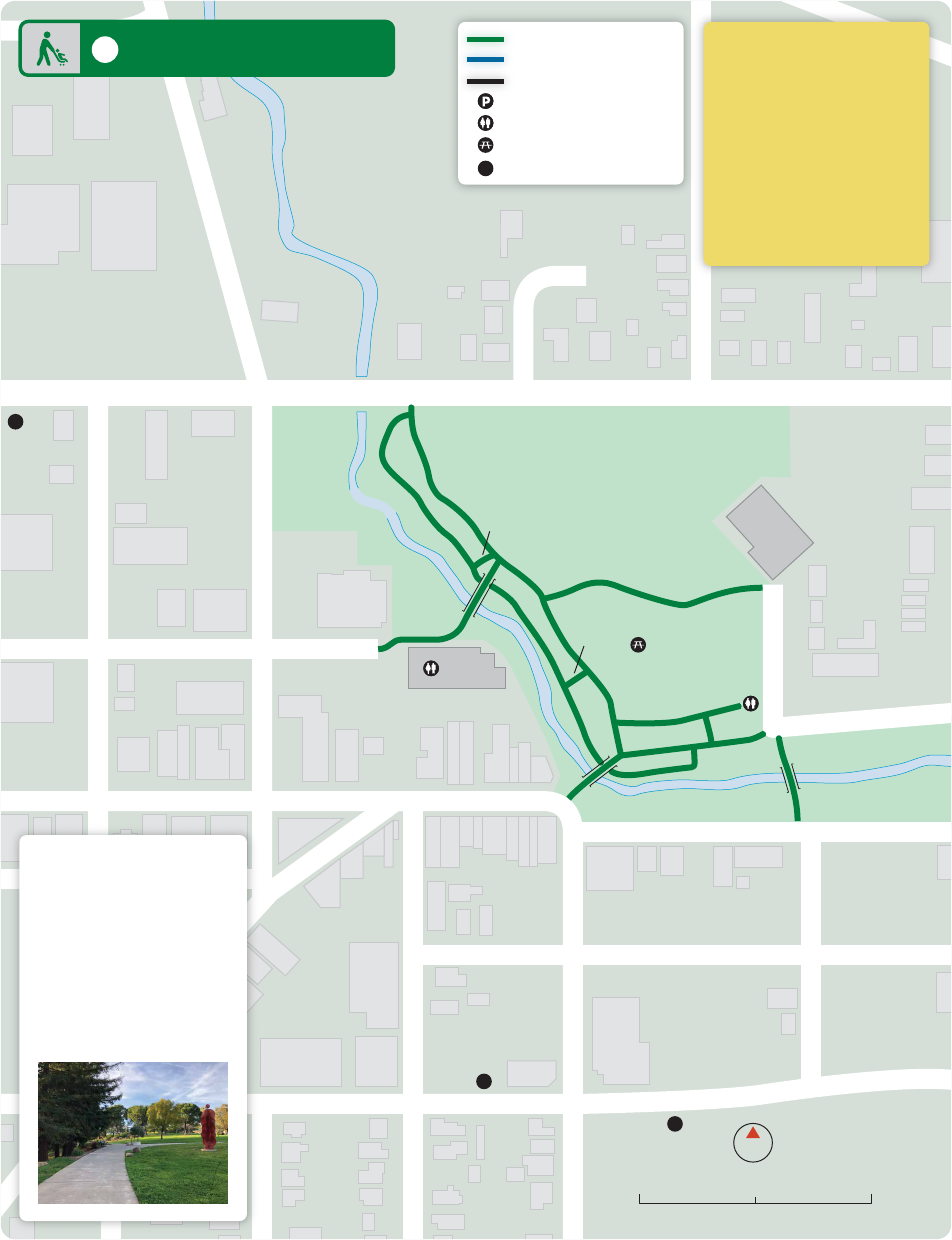
Difficulty Easy
Path Material Paved
Dog Friendly Yes
Parking Free
Public Restrooms Yes
Water Yes
Picnic Area Yes
Public Transit Vacaville
City Coach
Quick Facts
Quick Facts
4 Vacaville Creek Walk
You can hear a different
band every Friday evening
during the summer at the
Creekwalk concert series
in Andrews Park. Blues
Festivals, Chili Cook-offs,
Ladies' Nights and the
annual Halloween Stroll
near the creek in a parklike
setting keep the place
hopping during other
times of the year.
Easy Walking Route
Moderate Walking Route
Strenuous Hiking Route
Parking
Restrooms
Picnic Area
Bus Stop
B
B
B
B
u
p
h
i
l
l
u
p
h
i
l
l
u
p
h
i
l
l
Blue Rocks
Springs
Northgate
Neighborhood
Park
Blue Rock
Springs
Golf Club
Blue Rock
Springs
Golf Club
Vallejo Fire
Station 27
Peacock Roost
Picnic Area
C
o
l
u
m
b
u
s
P
a
r
k
w
a
y
A
s
c
o
t
C
o
u
r
t
C
o
l
u
m
b
u
s
P
a
r
k
w
a
y
R
e
d
w
o
o
d
P
a
r
k
w
a
y
N
o
r
t
h
A
s
c
o
t
P
a
r
k
w
a
y
S
t
J
o
h
n
’
s
M
i
n
e
R
o
a
d
E
a
g
l
e
R
i
d
g
e
D
r
i
v
e
P
e
b
b
l
e
B
e
a
c
h
D
r
i
v
e
S
u
n
r
i
v
e
r
L
a
n
e
C
h
e
n
i
n
B
l
a
n
c
P
l
a
c
e
C
a
b
e
r
n
e
t
D
r
i
v
e
M
e
l
o
d
y
L
a
n
e
P
e
n
n
y
L
a
n
e
H
e
a
d
w
a
t
e
r
D
r
i
v
e
R
o
c
k
y
S
h
o
r
e
D
r
i
v
e
S
a
w
g
r
a
s
s
L
a
n
e
E
d
g
e
w
a
t
e
r
P
l
a
c
e
Z
i
n
f
a
n
d
e
l
L
a
n
e
L
a
S
a
l
l
e
W
a
y
0 1000 Feet500
N
Difficulty Moderate
Distance 4 Miles
Type Out and Back
Path Material Dirt
Dog Friendly No
Parking $5/car (Apr-Oct)
Public Restrooms Yes
Water Yes
Picnic Area Yes
Public Transit SolTrans
Hours 8 am-Sunset
Quick Facts
Quick Facts
(weekends and
holidays, Apr-Oct)
Free on Ascot Court
5 Blue Rock Springs
5
The Blue Rock Springs Trail
provides access to the ridge
of the Sulfur Springs
Mountain for spectacular
views of Vallejo and
the Napa River. Look for
the Blue Rock Springs Park
trail entrance near
Peacock Roost picnic area.
Easy Walking Route
Moderate Walking Route
Strenuous Hiking Route
Other Trail
Mileage
Parking
Restrooms
Picnic Area
Bus Stop
1
.5
1
1.5
B
B
B
B
Rockville
Hills
Regional
Park
u
p
h
i
l
l
u
p
h
i
l
l
CORDELIA
GREEN
VALLEY
lake
pond
G
r
e
e
n
V
a
l
l
e
y
T
r
a
i
l
B
l
a
c
k
O
a
k
T
r
a
i
l
M
y
s
t
i
c
R
i
d
g
e
L
a
k
e
F
r
o
n
t
T
r
a
i
l
L
o
w
e
r
L
a
k
e
L
o
o
p
L
o
w
e
r
T
i
l
l
e
y
L
o
o
p
U
p
p
e
r
T
i
l
l
e
y
L
o
o
p
R
o
c
k
v
i
l
l
e
T
r
a
i
l
U
p
p
e
r
Q
u
a
r
r
y
A
r
c
h
T
r
a
i
l
O
u
t
s
i
d
e
L
o
o
p
D
e
v
i
l
’
s
B
a
c
k
b
o
n
e
B
a
y
A
r
e
a
R
i
d
g
e
T
r
a
i
l
M
i
d
d
l
e
M
y
s
t
i
c
L
o
w
e
r
M
y
s
t
i
c
B
l
a
c
k
O
a
k
G
r
e
e
n
V
a
l
l
e
y
T
r
a
i
l
U
p
p
e
r
M
y
s
t
i
c
Jockey
Junction
R
o
c
k
G
a
r
d
e
n
Q
u
a
r
r
y
F
e
r
n
F
a
l
l
s
M
a
n
z
a
n
i
t
a
L
o
w
e
r
T
i
l
l
e
y
L
o
o
p
M
a
y
-
D
e
c
e
m
b
e
r
T
r
a
i
l
U
n
k
n
o
w
n
T
r
a
i
l
B
a
y
A
r
e
a
R
i
d
g
e
T
r
a
i
l
Rockville Road
Rockville Road
Oakwood Drive
O
a
k
r
i
d
g
e
D
r
i
v
e
Emerald
Bay Drive
L
a
k
e
s
h
o
r
e
D
r
i
v
e
B
a
y
r
i
d
g
e
D
r
i
v
e
B
a
y
r
d
i
g
e
D
r
i
v
e
B
r
i
d
l
e
R
i
d
g
e
D
r
i
v
e
W
e
s
t
a
m
e
r
i
c
a
D
r
i
v
e
Suisun Valley Road
R
o
c
k
v
i
l
l
e
R
o
a
d
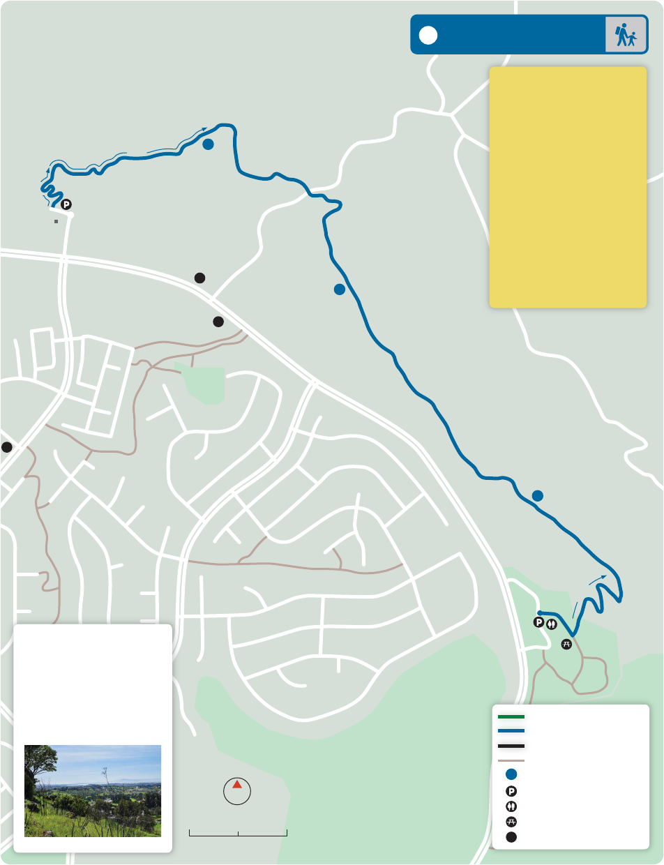
6 Rockville Hills
Difficulty Moderate
Distance 2.25 Miles
Type Loop
Path Material Dirt
Dog Friendly $1/dog (leash)
Parking $3/person
Public Restrooms Yes
Water No
Picnic Area Yes
Public Transit No
Hours Sunrise-Sunset
Quick Facts
Quick Facts
0 0.5 Mile0.25
N
6
633 acres of hills and valleys,
dense forests, open areas
and sky, with a lake, pond,
and blue oaks.
Easy Walking Route
Moderate Walking Route
Strenuous Hiking Route
Other Trail
Mileage
Parking
Restrooms
Picnic Area
.5
.25
1
1
1.5
2

u
p
h
i
l
l
u
p
h
i
l
l
u
p
h
i
l
l
u
p
h
i
l
l
HIDDENBROOKE
Hiddenbrooke
Golf Club
Vallejo Swett Ranch
(no public access)
Hiddenbrooke
Open Space
Hiddenbrooke
Trailhead
Hiddenbrooke
Summit
gate
H
i
d
d
e
n
b
r
o
o
k
e
P
a
r
k
w
a
y
M
c
G
a
r
y
R
o
a
d
B
e
n
n
i
n
g
t
o
n
D
r
i
v
e
B
e
n
n
i
n
g
t
o
n
C
o
u
r
t
H
i
d
d
e
n
b
r
o
o
k
e
P
a
r
k
w
a
y
S
o
n
g
w
o
o
d
R
o
a
d
H
i
g
h
g
a
t
e
R
o
a
d
L
a
n
d
m
a
r
k
D
r
i
v
e
80
C
o
n
n
e
c
t
o
r
T
r
a
i
l
B
a
y
A
r
e
a
R
i
d
g
e
T
r
a
i
l
0 0.5 Miles0.25
N
7
Difficulty Strenuous
Distance 4 Miles
Type Out and Back
Path Material Dirt
Dog Friendly Yes
Parking Free
Public Restrooms No
Water No
Picnic Area No
Public Transit No
Quick Facts
Quick Facts
7 Hiddenbrooke
View the San Pablo Bay, or
even the San Francisco Bay
on a clear day, as well
as Mt. Tamalpais and
Mt. Diablo.
Easy Walking Route
Moderate Walking Route
Strenuous Hiking Route
Other Trail
Mileage
Parking
Restrooms
1
.5
1
1.5
2
80
80
.5
.5
.9
1.5
.8
1
.25
u
p
h
i
l
l
u
p
h
i
l
l
u
p
h
i
l
l
u
p
h
i
l
l
dog
park
disc
golf
tower
Lagoon
Valley
Park
Peña
Adobe
Regional
Park
Jack
Hume
Grove
VACAVILLE
Lagoon
P
e
ñ
a
A
d
o
b
e
R
o
a
d
Cherry
Glen Road
Lagoon Valley Road
Lagoon Valley Road
R
i
v
e
r
a
R
o
a
d
C
h
e
r
r
y
G
l
e
n
R
o
a
d
Butcher Road
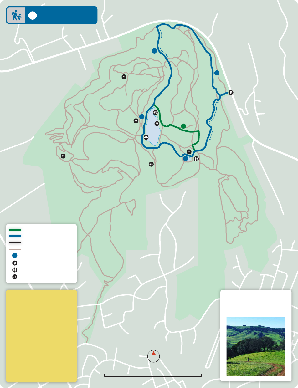
Difficulty Easy to Strenuous
Type Varies
Path Material Asphalt/Dirt
Dog Friendly Yes
Parking $3/car
Public Restrooms Yes
Water Yes
Picnic Area Yes
Public Transit No
Hours 7:30 am-Sunset
Quick Facts
Quick Facts
(free on Butcher Rd)
8 Lagoon Valley
0 0.5 Miles0.25
N
8
With over 470 acres of
unspoiled hiking and biking
trails featuring sweeping
views of the hills, plus
Lagoon Lake for fishing
and non-motorized boat-
ing, archery, disc golf, and
a large dog park, Lagoon
Valley Park is the perfect
natural respite. Bonus
points if you can find
the tree swing!
Easy Walking Route
Moderate Walking Route
Strenuous Hiking Route
Other Trail
Parking
Restrooms
Mileage between points
.5
.25
.75
1.25
1.75
2.25
2.75
3.25 4.25
4.75
5.25
5.75
3.75
80
80
80
u
p
h
i
l
l
u
p
h
i
l
l
u
p
h
i
l
l
u
p
h
i
l
l
M
i
d
d
l
e
V
a
l
l
e
y
T
r
a
i
l
N
o
r
t
h
R
i
d
g
e
T
r
a
i
l
S
a
d
d
l
e
T
r
a
i
l
P
r
a
i
r
i
e
R
i
d
g
e
T
r
a
i
l
K
e
s
t
r
e
l
T
r
a
i
l
S
o
u
t
h
V
a
l
l
e
y
T
r
a
i
l
L
y
n
c
h
R
o
a
d
T
o
w
e
r
T
r
a
i
l
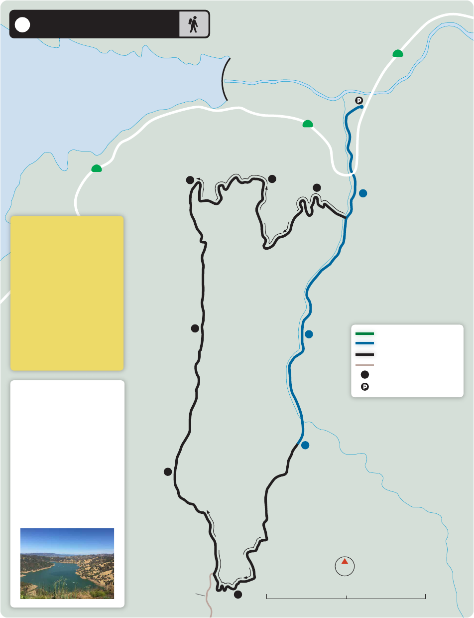
Lynch Canyon
Open Space Park
HIDDENBROOKE
M
c
G
a
r
y
R
o
a
d
M
c
G
a
r
y
R
o
a
d
H
i
d
d
e
n
b
r
o
o
k
e
P
a
r
k
w
a
y
A
m
e
r
i
c
a
n
C
a
n
y
o
n
R
o
a
d
Hiddenbrooke
Trailhead
see Hiddenbrooke
page 7
(private ranches;
no public access)
(private ranches;
no public access)
Hike the many hills on this
strenuous hike, with full
views of Vallejo, marshes,
and the surrounding hills
in the presence of a diverse
array of wildlife and plants.
0 0.5 Mile0.25
N
9 Lynch Canyon
Difficulty Strenuous
Distance 6 Miles
Type Varies
Dog Friendly No
Path Material Dirt
Parking $6/car
Public Restrooms Yes
Water No
Picnic Area Yes
Public Transit No
Hours 9 am-5 pm (Fri-Mon)
Quick Facts
Quick Facts
9
Easy Walking Route
Moderate Walking Route
Strenuous Hiking Route
Other Trail
Mileage
Parking
Restrooms
Picnic Area
1
1
.5
1.5
2
2.5
3
4.5
4
5
5.5
6
.5
1
3.5
128
128
128
uphill
u
p
h
i
l
l
u
p
h
i
l
l
u
p
h
i
l
l
u
p
h
i
l
l
abandoned
homestead
Putah Creek
State Wildlife Area
Stebbins Cold Canyon
Natural Reserve
Lake Berryessa
P
u
t
a
h
C
r
e
e
k
H
o
m
e
s
t
e
a
d
T
r
a
i
l
B
l
u
e
Ridge L
o
o
p
H
o
m
e
s
t
e
a
d
T
r
a
i
l
Annie’s Trail/
Tuleyome Loop
Wild Horse
Canyon
0 0.5 Mile0.25
N
10
Difficulty Moderate/
Strenuous
Distance 5.5 Miles
Type Loop
Path Material Dirt
Dog Friendly No
Parking Free
Public Restrooms No
Water No
Picnic Area No
Public Transit No
Hours Sunrise-Sunset
Quick Facts
Quick Facts
10 Stebbins Cold Canyon
Extreme topography gives
the reserve a mix of habitats,
high species diversity, and
beautiful views. Trails are
rough, steep and
strenuous. Some areas have
cliffs and steep drop-offs.
Views of Lake Berryessa and
surrounding mountains.
Bring water and food.
Stick to marked trails.
Start early as it may take
longer to hike than
anticipated. Bring a cell
phone in case you
need to call for help.
Easy Walking Route
Moderate Walking Route
Strenuous Hiking Route
Other Trail
Mileage
Parking
1
.5
1
1.5
2
2.5
3
3.5
4
4.5
A Street (Dixon) – Stroll through Downtown Dixon
Benicia by the Bay – Benicia State Recreational Area (see online for audio tour)
Benicia/Martinez Bridge – Cross the bridge that connects these two cities, and don’t forget to
visit the Benicia Historic Arsenal Park
Browns Valley Trail (Vacaville) – Neighborhood connects to a park, school, and day care center
Cordelia Trail (Fairfield) – Neighborhood trail system in Fairfield connects parks and schools
Laurel Creek Trail (Fairfield) – From Paradise Valley Golf Course to Matthew Drive
Ledgewood Creek Trail (Fairfield) – Rockville Road to Portsmouth Court
Linear Park Trail (Fairfield) – Throughout the city to Solano Community College
Mare Island Shoreline Heritage Preserve (Vallejo) – 215-acre park located at the south end of
Mare Island
Suisun City Waterfront – Events, restaurants, fishing, and boating in downtown
Vallejo Benicia Buffer – A greenbelt along the ridge line between the two cities
Vallejo Benicia Waterfront – Continue the 1st Street (Benicia) walk through the Benicia State
Recreational Area to Vallejo through Glen Cove
Looking for additional walks or hikes not featured in the
Top Ten Walks and Hikes in Solano County?
Here are a few to keep you going until a future edition
11
The Solano Transportation Authority, along with its partner agencies, are not responsible for the safety of people
walking or hiking, or others utilizing these maps. No representation is made or intended as to the safety or fitness of
suggested routes, their markings, and signage or as to the suitability of sidewalk, path, or trail surfaces for pedestrian
travel. It is the sole responsibility of individual pedestrians to adhere to all applicable laws, warnings, and postings
and to choose routes and facilities that are safe and appropriate for their skills.

Solano Pedestrian Advisory Committee
Solano Transportation Authority
423 Main Street
Suisun City, CA 94585
(707) 424-6075
sta.ca.gov
Printed February 2024
In cooperation with
and
Websites of Interest
Bay Area Ridge Trail
ridgetrail.org
California Walks
calwalks.org
California Department of Parks and Recreation
parks.ca.gov
Greater Vallejo Recreation District
gvrd.org
San Francisco Bay Trail
baytrail.org
Solano Land Trust
solanolandtrust.org
Solano Public Health
�
Vibe Solano
vibesolano.com
Visit Vacaville
visitvacaville.com
UC Davis Natural Reserves
naturalreserves.ucdavis.edu
For Emergencies Call 911
The Top 10 Walks & Hikes is on the
Xplore Solano app!
Download the Xplore Solano app on the
Outerspatial platform for more information
on Solano community events, trails, parks,
and open space destinations.
Xplore Solano offers one location to plan your
next outdoor adventure in Solano County!
www.xploresolano.com
